Showing posts with label markers. Show all posts
17 Jan 2018
Bloordale Village
Location: Brock Ave. and Bloor St. W.
Date photo taken: 9 June 2014
Bloordale Village is a bit different than most of the neighbourhoods featured so far on NeaTO. It refers to the stretch of Bloor Street between Lansdowne and Dufferin. To the north is Wallace Emerson and to the south is Brockton Village. In between sits Bloor and, like the areas around it, it's in the midst of a transformation. The House of Lancaster Gentleman's Club, Salvation Army and variety stores now sit side by side with art galleries, vinyl stores, and microbreweries. To follow what's new in the area, check out the Bloordale Village BIA's Facebook page.
12 Jul 2017
Blue Flag
Location: Toronto Islands
Date photo taken: 7 August 2015
Ever been to the beach and noticed a blue flag flying? If you have, it means that you can feel safe going for a dip. The Blue Flag program is an international certification administered by the Foundation for Environmental Education. In order to be awarded a blue flag, a beach has to meet strict criteria in four different areas: water quality, environmental management, environmental education and overall safety. Receiving a flag isn't the end of the process either. Water quality must be regularly tested and independent audits are done to ensure that standards remain high. During the season (June to Labour Day) Toronto tests water quality at its supervised beaches daily and results are posted on the Toronto Public Health website. A handy map on the site indicates which beaches are currently safe to swim at and which ones have Blue Flag certification.
28 Sept 2016
Emery Village
Location: Weston Rd. at Verobeach Blvd.
Date photo taken: 22 May 2015
Emery Village is located in the north west corner of the city, bounded by the Humber River on the west, Highway 400 on the east, Steeles to the north and Wilson Rd. to the south. Almost nothing is left of the small farming hamlet that once existed here, industry replacing farms in the post-war boom, when the North York Official Plan designated all lands north of Finch as industrial. In 2003 the Emery Village BIA was founded and one of their goals is to restore a sense of history to the area. These signs, along with historical plaques and historically-themed murals are part of this effort.
To get an idea of what this area looked like once upon a time, check out the historical images of Emery that are part of the Toronto Reference Library's digital archive.
13 Apr 2016
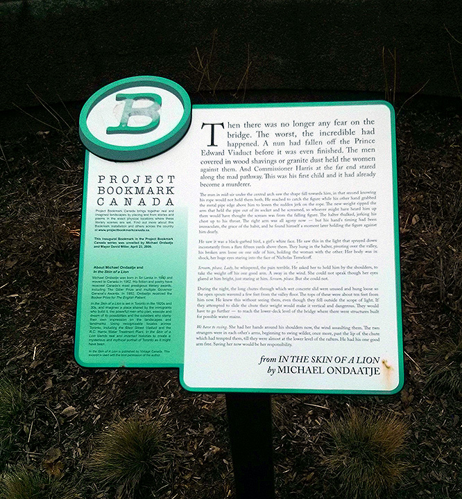
Project Bookmark
Location: North east side of the Bloor viaduct
Date photo taken: 11 April 2016
Project Bookmark is a unique project that takes passages from fiction and situates them in the real world. In this example, located at the eastern edge of the Prince Edward or Bloor viaduct, an early passage from Michael Ondaatje's In the Skin of the Lion describes a nun being swept off the bridge by the wind. It's a scene, and a book, deeply rooted in place. Readers of this plaque can take a few steps and experience the bridge for themselves, take in its height and be exposed to the elements. Combining the fiction and the reality in this way increases one's appreciation of both. It was an excellent choice with which to launch the program. To date, 15 bookmarks have been placed across Canada, and the 16th will be unveiled in Hamilton on June 10.
Do you have a favourite book or passage that is situated in Toronto, or elsewhere in Canada? Project Bookmark wants to hear about it - suggestions can be submitted through their website.
11 Sept 2013
Yellow Fish
Location: Langley Street
Date photo taken: 4 September 2013
Yellow fish like this one can be found painted on curbs all over the city. They are a key component of a program called Yellow Fish Road developed by Trout Unlimited Canada in 1991 to raise awareness about water pollution entering local water systems through storm drains like these. Water entering street grates like these generally flows through a series of tunnels and then emptys directly into the lake (although Toronto has undertaken some interesting projects to help add some filtering steps). Unlike water from houses, it is not usually treated before entering the lake so it is important to realize that anything washed into it, like detergent from washing your car, or salt put on your sidewalk, is going to affect the ecosystem into which it ultimately flows.
The Yellow Fish Road program engages youth, educating them about the effects of storm water run-off and then enlisting them to paint the fish on curbs and distribute literature to nearby homes. The Toronto and Region Conservation Authority is a partner in this program. If you want to involve your school class or youth group in this activity, you can submit an application through the TRCA website. It also makes a great team building exercise for corporate groups.
14 Aug 2013
Ghost Bike
Location: University Avenue at Richmond
Date photo taken: 3 July 2013
This white bicycle is a memorial to Mike Rankin, a veteran courier in his fifties who was killed in a collision with a taxi at this intersection in 2012. The front handlebar bears a small sign with Rankin's name and details.
The ghost bike memorial phenomenon is thought to have started in St. Louis, Missouri in 2003 when someone observing a bike-car collision placed a white bike on the spot with a sign reading "Cyclist struck here". Noticing that the bike had an effect on drivers, other bikes were installed throughout the city and the idea spread. While normally installed as tributes to cyclists killed by cars, a ghost bike in honour of Jack Layton can also be seen outside his former office on Broadview.
20 Feb 2013
Church Wellesley Village Sign
Location: Intersection of Maitland and Church Streets
Date Photo Taken: 26 October 2012
Image #1 in the Neighbourhoods Series
Long before Toronto became the grand metropolis it is today the area was populated by small villages. These were eventually swallowed up as the city grew but branded street signs now help to identify where these villages once stood. These signs also provide Business Improvement Areas and other neighbourhood groups the opportunity to identify their particular area. Many signs employ colour or graphics to impart a bit of the flavour of the community but as these existing signs age they will be replaced by the city’s new standardized signs. The new signs are made of extruded aluminum and covered in a highly reflective blue surface. The top panel still allows for a neighbourhood designation but a customized look will no longer be an option. The small numbers at the bottom of the sign indicate the street address closest to the intersection.
For a map of Toronto’s neighbourhoods, check out the one created by the Toronto Star.
Church Wellesley Village is Toronto’s largest LGBT community and the BIA hosts a number of street festivals and events throughout the year. The area is centered on Church Street, roughly between Gloucester St. and Wood St.
9 Jan 2013
Tree Tags
Location: Queen's Park
Date photo taken: 11 December 2013
Many trees around the city are now sporting small metal tags, just above eye level. Some of those tags are painted green. They mark ash trees that are healthy enough to be good candidates for inoculation by a product called TreeAzin™. TreeAzin™ helps protect ash trees against the ravages of the Emerald Ash Borer, an invasive insect species that has taken up residence in Toronto and threatens to wipe out the city’s population of ash trees by 2017. That’s about 860,000 trees. It’s too expensive to treat every tree, especially since it has to be repeated every two years, so the city is prioritizing high value trees. If you’re a home owner and have an ash tree on your property, take note: if it succumbs to the bug, and most experts expect that most untreated trees in the city will, you will be financially responsible for having the dead tree removed. For more information, visit the City of Toronto’s page on Emerald Ash Borers.
Date photo taken: 11 December 2013
Many trees around the city are now sporting small metal tags, just above eye level. Some of those tags are painted green. They mark ash trees that are healthy enough to be good candidates for inoculation by a product called TreeAzin™. TreeAzin™ helps protect ash trees against the ravages of the Emerald Ash Borer, an invasive insect species that has taken up residence in Toronto and threatens to wipe out the city’s population of ash trees by 2017. That’s about 860,000 trees. It’s too expensive to treat every tree, especially since it has to be repeated every two years, so the city is prioritizing high value trees. If you’re a home owner and have an ash tree on your property, take note: if it succumbs to the bug, and most experts expect that most untreated trees in the city will, you will be financially responsible for having the dead tree removed. For more information, visit the City of Toronto’s page on Emerald Ash Borers.
Subscribe to:
Posts (Atom)