Showing posts with label signs. Show all posts

17 Apr 2025

Drink Canada Dry


Large light-box style sign hanging over the street, advertising Canada Dry ginger ale

Location: 900 Queen Street East   
Date photo taken: 28 April 2019

This awesome vintage Canada Dry sign hangs out front of Eddie's Convenience on Queen Street East just west of Logan. Whenever I see vintage signs like this, I wonder about their story - when they were first hung and how it is that they have survived. So I turned to the city directories to see if I could discover anything. It turns out that Eddie's Confectionery, the business name that appears in faded letters at the top of the sign, first appears in the city directory at this location in 1954, operated by Sylvia Rosenbloom. The "Eddie" is explained if you look further back. In earlier years, the listing for this address simply read "Rosenbloom, Edward, confy". 

With stores on retail strips coming and going and changing from one type to another, it was interesting to me to discover that since this address first appeared in the city directory in the late 1900s, it has been occupied by a number of different people - Norman Shier, Geo Sernissi, Nathan Besserman, and perhaps others - but it was always a confectionery.

26 Sept 2024

Limelight Hydrangeas

View of hydrangea flowers, next to a sign explaining what they are

Location: Berkeley Street 
Date photo taken: 18 September 2024

Walking up Berkely Street, there's a garden bed planted with small shrubs that have for some time been simply overflowing with the most magnificent flowers. Thanks to the signage so thoughtfully included by whoever planted these, I know that they are Limelight Hydrangeas and that I should be able to appreciate the blooms for a few more weeks yet. While there are great apps to help the curious identify plants, I love that in this case, I didn't have to pull out my phone to know what I was looking at, especially considering that this bed isn't part of a city park or associated with a garden centre.

29 Jun 2023

You're like, really pretty


Location: Distillery District
Date photo taken: 19 June 2023

Over the last few years, bit by bit, the nighttime city has been getting brighter and more colourful thanks to a proliferation of neon-style LED signs. Once a more rarified being, neon signs used to be a beacon for those looking for the it place to be, but the new technology makes them decidedly more attainable and as a result, much more common. Now you're as likely to see one at your local coffee shop or ice cream parlour as you are at the latest hot spot. This one is outside Miss J Lash Lounge in the Distillery.

13 Apr 2023

Beware: red-winged blackbirds

 warning sign affixed to a fence, marshy grasses in background. features images of a bird with red capped wings.

Location: Corktown Common
Date photo taken: 12 October 2021

Living in Toronto, most of us have been conditioned to recognize robins as one of the early signs of spring. In terms of feathered harbingers of nicer weather to come, I would also put forward the red-winged blackbird. While perhaps less evenly distributed across the city than robins, they are very common in Southern Ontario and just as distinctive. If you spend any time in parklands that are near water, you have likely seen them. Their bright red epaulets make them highly visible, and they're pretty loud as well. If you hear one in the spring, I advise you to not to stare. As the sign above notes, "Birds may exhibit aggressive behaviour protecting their young." Showing too much interest may lead to a close encounter. As someone who has experienced this first hand, it's not an experience I care to repeat. If you hear a red-winged blackbird, especially in the spring, I suggest you try to remain as non-threatening as possible: stick to the path, keep moving and do not stare or actively search out the nest.  

26 Jan 2023

TD Rabbit


Illuminated sign on a tower on top of a building. One side features the TD Bank logo, the other a rabbit.

Location: above Bay and Front Streets
Date photo taken: 25 January 2023

The TD sign, now such a visible part of the city's night sky, first appeared in 2000. That was when TD Bank purchased Canada Trust and took over their building at 161 Bay Street, replacing their logo with the TD shield. At that time, the four sides of the sign were made up of a collection of 325 green and white neon tubes. In 2020, a major renovation was begun to convert the sign to LEDs which made the sign both brighter and more energy efficient. It also allows the display to be programmed to show things other than the logo. Like this rabbit, which commemorates the start of the Year of the Rabbit in the Chinese calendar.

19 Jan 2023

No Exit

No exit sign with additional clarifying text. Leafy street in the background, with fall colours

Location: South Kingsway and Morningside Avenue
Date photo taken: 11 November 2021

As someone who considers walking a hobby, I've always taken No Exit signs with a grain of salt. Unless I'm in a hurry, I usually don't mind risking a bit of backtracking, just to see where the road leads. That's not to say that I don't find the single-minded focus of the signs annoying. At one point I even considered making little Ampelmännchen decals to slap on signs that provided incorrect information to pedestrians, but discovered I was too short to apply them. Now, thanks in large part to the efforts of Walk Toronto, a pedestrian advocacy group, the City of Toronto has changed its approach to these signs. Starting in 2021 they began installing versions which provide greater clarity regarding the types of egress possible. With over 450 locations of inaccurate signage identified by Walk Toronto, its likely going to take a while to switch them all, but every new addition makes a difference. 

9 Mar 2022

Clairlea


Location: Kingswell Crescent and Pharmacy Avenue
Date photo taken: 27 February 2017

In June 1950 the Toronto Star was full of ads for bungalows and two-storey homes in Clairlea, "the east end's newest subdivision". Located on the western edge of Scarborough and bordered by Victoria Park, Warden, Eglinton and St. Clair, the neighbourhood featured a park and a school and modern shopping district were under construction. The ads for the 6-room bungalows ran as follows: 

These solid brick bungalows have everything. Large, bright living with full dining room adjoining. Modern, gleaming tile kitchen with lots of cupboards. 3 good size bedrooms with clothes closets in each. 4-piece tile bathroom. Steel beam construction. Divided basement with recreation room facilities. All on wide lots with private drive. 

All for just $9,950.

15 Dec 2021

Pizza Pizza

Pizza Pizza sign in old script-style lettering, with little chefs forming the "i"s - on the side of a building, orange and white vertical stripes beneath

Location: Broadview & Danforth
Date photo taken: 3 June 2019

I just love the little pizza-tossing figures in this signage and I'm so happy that even though this location looks just like every other Pizza Pizza from the front, this eye-catching signage was retained on the side. The colour palette is different and the "i"s looked more like regular letters, but the script style here matches that on the sign which hung above the original location at Wellesley and Parliament, which opened in 1967. Here are some other fun facts from the archived version of the Pizza Pizza corporate history site: 
  • In 1967 Pizza Pizza worked with a car upholsterer to create the world's first insulated pizza delivery bag.
  • The famous 11-11 phone number was introduced in 1975 and worked into the catchy jingle in 1978.


1 Dec 2021

Dovercourt Village

 Street sign for Shanly Street, topped with a special design denoting Dovercourt Village

Location: Shanly Street at Salem Avenue
Date photo taken: 3 October 2013

Dovercourt Village is a small neighbourhood in the city, focused along Dovercourt Road and Hallam Street. It's part of the larger Dovercourt Park, which stretches north from Bloor to the railway tracks, between Ossington and Dufferin. Initially a suburb of the city, Dovercourt was annexed on January 2, 1888 although at this time, still relatively little had been built here. The train tracks, which were part of the Ontario & Quebec Railway line connecting Toronto and Perth, had been completed in 1884 but the city atlas from the same year shows precious little other development. By 1890 there were a few more buildings scattered about but not much had changed with the notable exception of the street names. Durham had become Shanly. Brighton Place, Hallam. Dover Court would lose its space and Lancaster would become Ossington. The turn of the century was a boom period for the city however and it didn't take long for development to come to Dovercourt. By 1910, the atlas shows almost every lot developed.

The 1985 on the sign likely refers to the establishment of the Dovercourt Village BIA.

22 Sept 2021

Attention - Coyotes

 Sign on post in wooded area, filled with information on coyotes and what to do if you encounter one

Location: Bloordale Park North
Date photo taken: 25 November 2021

With Stanley Park's coyotes in the news lately, I thought I would share some local coyote information. With all of our parks and ravines, it's not surprising that Toronto is home to coyotes but did you know that the City of Toronto offers an e-learning course called Coyotes in the Urban Landscape? There's also a webpage that sets out lots of tips and information on what to do and not do when you encounter a coyote. My favourite is definitely Be big and loud: Jump up and down, wave your arms, yell “Go away coyote!” It's not just a bit of fun - yelling "Go away coyote" alerts nearby pedestrians and pet owners that there's a coyote in the vicinity. Other take-aways include: do not approach them, never feed them,  and do not turn your back or run away from them.

24 Mar 2021

For the greener good

 Tree with a green ribbon around it. Hanging from the ribbon is a page of information enclosed in plastic - "Riverside Green Ribbons"

Location: Bruce Mackey Park
Date photo taken: 21 March 2021

If you've spent any time in Riverside lately, you've probably seen a tree or two wrapped in a green plastic ribbon. I don't know when they first started appearing, but I first encountered them shortly after St. Patrick's Day. I have to admit I was a bit irked. I assumed someone had decided to green up their neighbourhood for the day and was in no hurry to reverse the process. I am therefore thankful to whoever it was who had the foresight to attach plastic-covered information sheets to a smattering of the trees. The green ribbons are part of a campaign by local residents to raise awareness about the new Ontario Line and the effects that it will have on their neighbourhood. While much of the line will be underground, the portion running through this area will be built at level, adjacent to the existing rail corridor. This happens to be where most of the green space and recreational facilities are located, putting them at risk. Save Jimmie Simpson! is working to engage residents in the fight to have this portion of the line buried. Visit their site to learn more. They've also got some cute buttons for sale.

13 Jan 2021

Blast from the Past - Lick's Homeburgers & Ice Cream


Large stand-alone vintage-inspired sign for Licks, featuring a graphic of a hamburger, milkshake and strawberry ice cream cone

Location: 1585 The Queensway
Date photo taken: 12 May 2014

This week's post offers up a double dose of nostalgia. Licks was a Canadian fast food chain that offered up better than average food, including their meatless Natureburger and decadent milkshakes. The chain actually started with a single ice cream parlour, opened in 1978. The 1970s, especially the later years, experienced a spate of 1950s inspired movies, music and television (think Grease and Sha Na Na) which carried over to general culture, and obviously influenced the branding at Licks. I just love the nostalgic vibes coming off this sign! 

When I snapped this picture, the chain's decline was already well advanced, with the flagship location having closed in 2012 and many of the franchises closing in the subsequent year. While they have largely disappeared, Licks' demise was not total. A Google search has revealed a lone Lick's Homeburgers & Ice Cream on the Golden Mile, and according to their menu, their milkshakes are still made with real ice cream.

13 May 2020

Wexford Heights

Lawrence Ave street sign with Wexford Heights banner at top, 3 metal bug sculptures on the pole

Location: Lawrence and Crockford
Date photo taken: 27 February 2017

Wexford Heights stretches along Lawrence Avenue between Victoria Park and Birchmount and is part of the larger Wexford / Maryvale neighbourhood in Scarborough. The local BIA was formed in 2004 and the jewel in their crown is the Taste of Lawrence Festival. Celebrated each year in July, it is Scarborough's largest street festival and as the name implies, food plays a central role in the festivities.

I admit when I took this picture, it was as much about the butterflies attached to the post as it was about the Wexford Heights sign. These critters were made by AC Waterjet Inc., a business located just down the road. They also have some much larger creatures on display next to their showroom but that's for another post.

15 May 2019

Bracondale Hill


Location: Hillcrest Drive and Bracondale Hill Road
Date photo taken: 8 October 2015

Bracondale Hill is a residential neighbourhood located north of Davenport, between Bathurst and Oakwood. It takes its name from the stately home built by Robert John Turner about 1847, located at Davenport and Christie. When Turner's son inherited the estate, he helped establish Bracondale Village, selling hundreds of building lots around the home and building the village's first post office. In 1909 Bracondale was annexed by the City of Toronto. The date on the sign refers to the subsequent development of another subdivision by the Turner heirs on lands to the north and west of their family home. The character of the neighbourhood was set by the inclusion of a minimum construction cost per house. This varied between $4,000 and $7,500 depending on the location, quite significant sums for the period. The house that started it all was expropriated by the City in 1930 and demolished in 1937 to make way for Hillcrest Park.

12 Sept 2018

Frederick and Duke

Corner of building with stone insert showing the street names 'Frederick' and 'Duke'

Location: Corner of Frederick and Adelaide
Date photo taken: 7 February 2018
Image 8 in the Remnants Series

This stone marker on the corner of George Brown's St. James Campus building is not a reference to Shakespeare but rather a reminder that Toronto is a city in constant flux. Back when this building was built in 1872 by Christie Brown & Co., maker of good cookies, the streets which ran east to west between King and Queen looked different than they do today. They were more disjointed and in some stretches they were called by different names. As seen on this 1884 fire insurance map, the street which ran between Jarvis and Parliament, north of King, which is today part of Adelaide, was at that time Duke Street. North of it was not Richmond, but Duchess. Hence, this now curious street marker.

21 Feb 2018

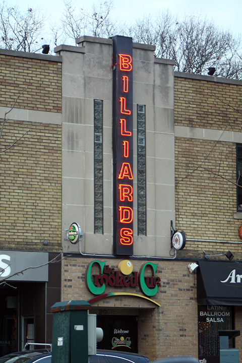
Kingsway Billiards


Location: 3056 Bloor St. W., near Royal York
Date photo taken: 9 January 2017

The Crooked Cue pool hall and restaurant has been in this Bloor Street West location since 1992 but the building has been dedicated to recreation since its first tenant opened its doors in the late 1940s. The Toronto Star ran a notice announcing the opening of the 16 lane Kingsway Bowling Academy on September 19, 1947. The Pappas family bought the building in the 1950s and eventually bowling gave way to billiards. The old school pool hall with its snack bar was renovated in 1992 when the next generation of the Pappas family took over, adding a full bar and restaurant. I'm not sure when during the building's history the neon sign was installed but I love it.

17 Jan 2018

Bloordale Village


Location: Brock Ave. and Bloor St. W.
Date photo taken: 9 June 2014

Bloordale Village is a bit different than most of the neighbourhoods featured so far on NeaTO. It refers to the stretch of Bloor Street between Lansdowne and Dufferin. To the north is Wallace Emerson and to the south is Brockton Village. In between sits Bloor and, like the areas around it, it's in the midst of a transformation. The House of Lancaster Gentleman's Club, Salvation Army and variety stores now sit side by side with art galleries, vinyl stores, and microbreweries. To follow what's new in the area, check out the Bloordale Village BIA's Facebook page.

15 Nov 2017

Slow Down Homie


Location: King Street W. and Tyndall Ave.
Date photo taken: 12 May 2014

Signs with pictures of turtles imploring drivers to "please drive slowly" can be found throughout the city. This one, in Parkdale, puts a unique spin on it.

This fall the City of Toronto has launched a new community safety program in the form of lawn signs encouraging drivers to slow down. The signs come in orange and blue and feature two different designs. Homeowners interested in obtaining a sign for their lawn should contact their local councillor


14 Jun 2017

Patrician Grill

Sign for the Patricial Grill - Good Food, with GRILL in neon

Location: 219 King St. E. near Sherbourne
Date photo taken: 16 September 2013

The Patrician Grill is exactly what you'd expect, based on the sign. It's a diner serving up comfort food standards like burgers and meatloaf and it's been doing it since the 1950s. Family owned and operated, first by husband and wife team Louie and Helen Papas, and now by the next generation, it remains true to its roots. Stubbornly so. As one story goes, when a note was slipped under the door criticizing them for not having fruit on the menu, the specials board soon read "Fruit-free since 1967". Reviewers on sites from Google to Trip Advisor agree though that good food is exactly what you'll find inside. 

5 Apr 2017

Zanzibar Circus Tavern


Exterior of the Zanzibar strip club. Facade is covered in gold, with neon stars and dancing girls

Location: 359 Yonge St., just south of Gerrard
Date photo taken: 4 April 2013

Club Zanzibar is a bit of a relic. It's one of only 16 active "adult entertainment clubs" operating in the city of Toronto and one of only a few left in the downtown core. Back in 1978 the city changed its land use rules making it pretty much impossible to open a new strip club, but it allowed the 63 currently in existence to remain open. Over the years, that number has dwindled but the Zanzibar has remained. Its gold facade and neon lights are now an icon on the Yonge Street strip. The building wasn't always a strip club of course. Before Zanzibar it housed various businesses, such as a butcher's and a photography shop. Right before it was Zanzibar it was the Rosticceria Tavern. The Zanzibar Tavern first opened its doors in 1959 as a live music venue, part of the happening Yonge Street music scene. By the late 1960s it still featured live music but it was more of a dance club, complete with topless go-go dancers. In the 1970s it made the switch to strip club and the show hasn't stopped since.

Note: The TD Gallery at the Toronto Reference Library is currently hosting an exhibit that looks at the city's early attempts at moral reform. Vice & Virtue is on until April 30 and it's free.